When it comes to land development, home construction, or even simple property purchases, understanding the different types of land surveys is crucial. Among the most commonly requested surveys are site plan surveys and boundary surveys. While both provide essential information for property owners and developers, they serve different purposes and involve distinct methodologies. Whether you’re building a new home, installing a fence, or subdividing land, knowing the difference between these surveys can help ensure your project complies with local regulations and avoids legal disputes.
In this article, we’ll break down what each type of survey involves, when you might need one over the other, and what exactly is included in the final deliverables.
What Is a Boundary Survey?
A boundary survey is a precise assessment of a property’s legal boundaries. It identifies the corners of a parcel of land, marking the edges that define ownership. Licensed surveyors use historical records, physical evidence, and field measurements to establish boundary lines, which are often physically marked with pegs or stakes.
Boundary surveys are often required before purchasing or selling property, resolving boundary disputes, or making improvements near property lines. The goal is to clearly define where one property ends and another begins.
Elements of a Boundary Survey Include:
- Legal property description analysis
- Location of corners and monuments
- Boundary line identification and staking
- Encroachments or easement identification
- A certified survey map for official records
When Do You Need a Boundary Survey?
A boundary survey becomes essential in several scenarios:
- Property Transactions: Before buying or selling land, a boundary survey confirms the property’s legal description and size.
- Fencing or Landscaping: If you’re installing a fence or making landscaping changes near a boundary, a survey ensures you’re staying within legal limits.
- Resolving Disputes: In the case of neighbor disagreements or unclear boundaries, a boundary survey offers legal clarity.
- Subdividing Property: To legally divide a property into smaller lots, a boundary survey is typically the first step.
Boundary surveys can help prevent costly legal battles and ensure that all parties involved understand the true scope of a property.
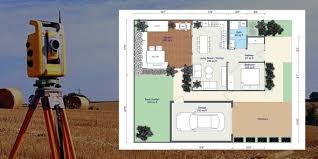
What Is a Site Plan Survey?
A site plan survey, sometimes called a plot plan, provides a detailed drawing of existing and proposed improvements on a property. This survey is more comprehensive than a boundary survey and is often used in the planning or permitting phase of a construction or development project.
While it includes boundary information, the focus is on how structures, driveways, utilities, and other improvements interact with zoning codes and planning regulations.
Key Components of a Site Plan Survey:
- Property boundaries
- Existing structures and improvements
- Proposed construction plans
- Setback requirements
- Drainage and grading plans
- Utility lines and easements
- Driveways, walkways, and landscaping
When Is a Site Plan Survey Required?
Site plan surveys are most commonly required by local councils or planning departments when applying for building permits. Typical scenarios include:
- New Construction: Before building a house, commercial building, or extension, a site plan is usually required for permit approval.
- Major Renovations: When making substantial changes to an existing structure, a site plan ensures compliance with zoning regulations.
- Land Development: Developers need a site plan to demonstrate how a parcel will be used and accessed, including compliance with environmental and infrastructure guidelines.
Because site plans are central to the approval process, they must be created by qualified professionals who understand both legal requirements and council standards.
Key Differences Between a Boundary Survey and a Site Plan Survey
While both surveys involve understanding property boundaries, their purposes and applications are quite different:
| Feature | Boundary Survey | Site Plan Survey |
| Purpose | Defines legal property boundaries | Shows existing and proposed improvements |
| Required For | Legal disputes, property transactions | Building permits, development planning |
| Includes Structures? | Usually no | Yes |
| Includes Zoning Info? | No | Yes |
| Level of Detail | Focused on property lines | Broader – includes topography and utilities |
| Legal Requirement? | Often required for property sales | Required for construction permits |
In essence, a boundary survey defines where your land is, and a site plan survey shows what you can do with that land.
What’s Included in Each Type of Survey?
Boundary Survey Includes:
- Surveyor’s legal boundary assessment
- Location of permanent markers
- Written legal description of the parcel
- Encroachment or easement notes
- Survey certification by a licensed professional
Site Plan Survey Includes:
- All features from a boundary survey
- Existing and proposed structures
- Utility connections and access points
- Driveways, easements, grading plans
- Compliance with zoning and building regulations
For larger or complex projects, both types of surveys may be required to satisfy council or regulatory requirements. Engaging with experienced land development consultants and surveyors ensures the appropriate surveys are conducted to meet your legal and planning needs.
Conclusion
Understanding the difference between a site plan survey and a boundary survey is essential whether you’re a homeowner, property developer, or commercial builder. A boundary survey gives you the precise legal edges of your property, while a site plan survey helps you plan and build within those edges. Both are critical tools in responsible land ownership and development.
Before undertaking any land-related project, it’s best to consult a licensed surveyor or land development professional who can guide you on which survey is appropriate for your needs. This helps avoid costly mistakes, ensures legal compliance, and smooths the path for your future development or sale.
For further in-depth guidance on surveying and property development, check out the National Society of Professional Surveyors and The New Zealand Institute of Surveyors for valuable insights and standards.
Frequently Asked Questions
When do I need a site plan?
You typically need a site plan when applying for a building or development permit. Councils use site plans to assess how proposed construction will impact surrounding properties, access ways, drainage, and zoning compliance.
Who creates a boundary survey?
Boundary surveys must be conducted by licensed professional surveyors. They use historical records, cadastral data, and physical measurements to accurately determine legal property boundaries.
Who prepares a site plan?
Site plans are usually prepared by licensed surveyors, architects, or civil engineers with knowledge of planning regulations. In most cases, a surveyor will provide the base information, and an architect or designer may complete the plan with proposed structures and features.